Day 17 Raetihi to Whanganui
- Colin Grierson
- Mar 9, 2024
- 4 min read


The alarm wakes us at 6:30 to the sound of rain, we debate options and what to do - while lying in bed. By 7 we are up and having breakfast. The forecast is 'showers', anyway the rain has stopped and we will go regardless.
Outside I meet Ron, an early riser, there is a duck in the driveway, is it an omen? Ron says no, they are greedy and Alison is a soft touch and feeds them every day.
Packed, we farewell Ron, Alison is having a shower and misses out on a hug.

The morning is our coldest yet so we are well wrapped up. It's not raining :-) A final visit to the reliable Four Square for more instant noodles and we are on our way for real.
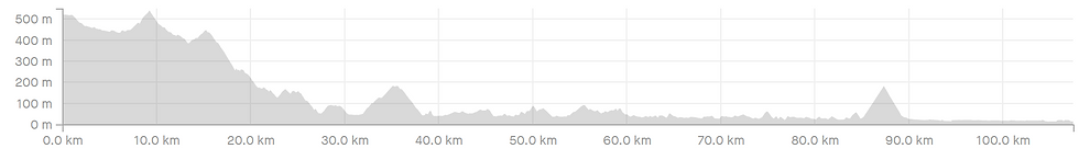
I do not examine our routes in detail, I know where we will go and the total climb for the day, but not much more. I prefer to discover the road as we travel. Some of the riders we met had Garmin Navigators that warned them of every approaching hill and gave the total climb remaining for the day - I think that would be disheartening and take your focus from where it should be - appreciating what is around you. Anyway I had expected the road to be more or less downhill all the way to Pipiriki but no. We had a decent downhill run but now we are climbing right back up again. Descend again then another climb, not as large this time. I'm finding the climbs easier - or maybe I have learned to take them slower...

We are in forest now. This is the big descent, I feel like we have been going down forever. I find descents emphasize how high a few hundred meters of elevation is more than the climbs do. Amazing how we keep on going down... Where is the bottom? The roads are extremely quiet and riding is really good. We've had a light shower but the weather is looking hopeful now. Finally the descent brings us to Pipiriki, 27km, our first milestone today. So we stop - at the public toilets - there is no cafe or coffee here. There is the Whanganui river! It's far different to when we saw it behind Taumarunui. Now it is big, chocolate brown and moving fast. Is it always this brown?


The river road is nice riding. I drove this once long ago when it was all gravel, now it is sealed all the way - but I don't think it's changed much otherwise, it is still quite narrow in places. Sometimes the road is close to the river, sometimes further away - and higher - but the climbs are gentle and always followed by longer descents. Again we have extremely enjoyable riding, today through this river valley - huge steep sides here - the powerful river often visible.


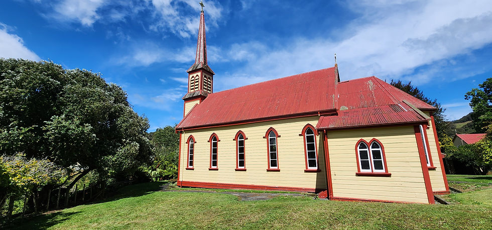
12 kilometers downstream we come to Jerusalem just as a shower arrives, we find shelter at the Sisters of Mercy convent just in time and have lunch as it rains. A large convent (living quarters) A Church. A few ancillary buildings, one having a sheltered picnic table where we are. It feels deserted. While we are eating two groups of people, one on e-bikes, arrive to look around. We had considered staying here tonight but got no answer when we called. After our lunch the rain has passed and we look around. Everything is open. Kitchen, lounge, dining room. All big, functional and extremely clean. A note says 'Please donate $40 if staying' and gives a bank account number. Upstairs the dormitory beds. No one is around except us. It's a very impressive institution, we wish it well.


The weather is still fine and no rain threatening, we ride on. The valley widens in places and we pass farms and small towns. The names amuse us - Jerusalem, London, Athens. What were the people who named them thinking?


That there are so many towns in such an isolated area feels strange too - but the river is navigable, so in the early days these were relatively accessible areas.

Finally a long climb to the ridge line giving us some great views of the river. Sau Keng is impressed by a grove of silver poplars, the wind is quite strong now, blowing the leaves from us so we see the white undersides "Looks like snow" says Sau Keng. I'm biased as silver poplars sucker and are often a weed, I needed Sau Keng to show me. At the top I check the map. The river seriously meanders here, looking at the tight turns it probably has high steep sides and leaving the valley here is the only option. The downhill run takes us back to SH4 but we only have to follow it three kilometers to Upokongaro where a cycle bridge takes us across the river to the Whanganui river cycleway, which takes us all the way into town.

The last battery for the trike is showing red so we are happy to be here (it's not that dire, the batteries go for a while on red, and the other two have a bit left. Our fault, we thought we had them all fully charged but one of the smaller batteries was only at half)

The motel where we intended to stay is full. So is the one beside it. Is there something on? Sau Keng gets onto her phone and finds a vacancy, it's further from town (and restaurants) but only by 1.6 kilometers and we do not feel like being picky.
Our room is comfortable and clean. A bathroom scent device is pervasive (we unplug, cover and open windows) It's not for us.
Rest, shower, decide not to ride into town for dinner. A classic Kiwi Chinese takeaway is just 900m away. Sau Keng won't buy Chow Mein or Chop Suey! Instead we get fried rice & egg foo young. They are tasty and the helpings are very generous - breakfast is sorted.
Statistics
Distance: 107.5 km
Climbed: 1313 m Surprise. For a heavily downhill day, our third highest!
Time: 7:21


Comments